
Understanding the Fundamentals: How Does Watershed Work?

Ever wonder where the water goes after it rains? It doesn't just disappear, you know. It all flows somewhere, and the land area that guides this water is called a watershed. Understanding how a watershed works is pretty important, especially when we think about things like floods, clean water, and how we use the land. It's like a giant natural system that connects everything, from the highest hills to the biggest rivers. Let's break down what makes these areas tick.
Key Takeaways
- A watershed is simply the land area where all the water drains to a single point, like a river, lake, or ocean. Think of it as a bowl where rain or snowmelt collects and flows downhill.
- Water moves through a watershed in two main ways: by soaking into the ground (groundwater) or by flowing over the land's surface (runoff).
- Natural features like soil and plants play a big role in cleaning water. As water seeps into the ground or flows through vegetation, it can filter out pollutants.
- The physical traits of a watershed, like its size, shape, and how steep it is, significantly affect how water moves and how quickly it reaches the outlet. These traits can influence flood risk and erosion.
- Knowing how watersheds work helps us manage resources better, from planning flood control and preventing soil erosion to guiding farming and building roads and bridges.
Understanding What a Watershed Is
So, you're probably wondering what exactly a watershed is. It sounds kind of technical, right? But honestly, it's a pretty simple idea once you get it. Basically, a watershed is just a land area where all the water that falls on it eventually drains to a single spot. Think of it like a giant, natural bowl. Any rain or snowmelt that lands inside that bowl will flow downhill, collecting in streams, rivers, lakes, or even underground, all heading towards the same exit point, or outlet.
Defining A Watershed's Boundaries
Every watershed has an edge, and we call that edge a drainage divide. You can picture this as the rim of our natural bowl. If you're standing on the highest ground around, you're likely on a drainage divide. Water falling on one side of that divide will flow into one watershed, and water falling on the other side will go into a completely different one. These boundaries aren't always obvious mountains; sometimes they're just gentle slopes or ridges. It's all about where the land directs the water.
The Role Of Drainage Divides
Drainage divides are super important because they're what separate one watershed from another. They dictate where the water goes. Imagine a raindrop falling. If it lands on the north side of a divide, it might end up in the Mississippi River. But if that same raindrop falls just a few feet away on the south side of the divide, it could be heading towards the Great Lakes. These divides are the invisible lines that manage the flow of water across the landscape.
Watersheds Of Varying Scales
Here's the cool part: watersheds aren't all the same size. They can be tiny, like the area that drains into a small pond in your neighborhood, or they can be absolutely massive. The Mississippi River watershed, for example, is enormous. It covers a huge chunk of North America, collecting water from 31 U.S. states and two Canadian provinces before it all flows out to the Gulf of Mexico. So, whether it's a small local stream or a major river system, it's all part of a watershed.
Here's a quick look at how different scales can work:
- Small Watershed: Might be a few acres draining into a local creek.
- Medium Watershed: Could be a whole county draining into a larger river.
- Large Watershed: Encompasses multiple states or even countries, draining into an ocean.
It's easy to think of water as just falling from the sky and going away, but it's all connected. What happens upstream, even miles away, can affect what happens downstream. That's why understanding watersheds is so key to managing our water resources.
How Water Moves Through A Watershed
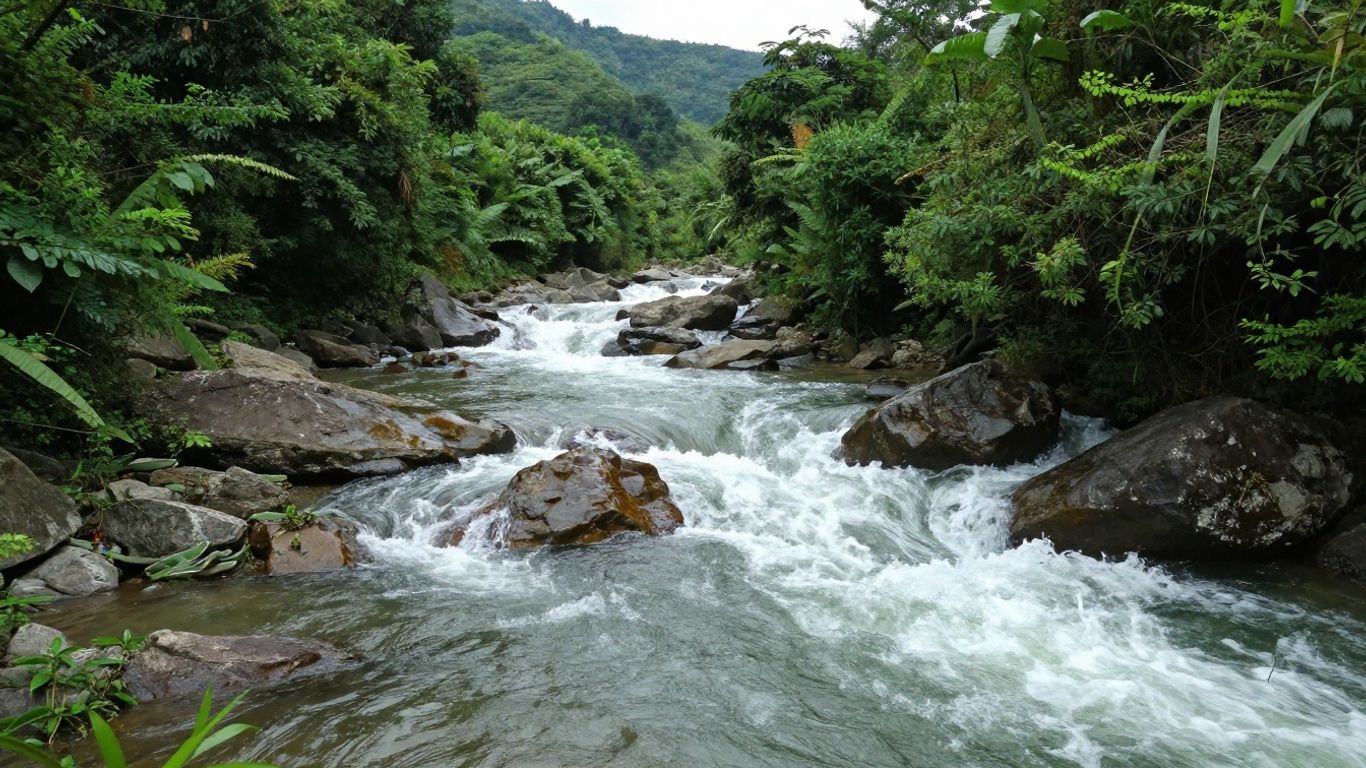
So, water falls from the sky, right? But where does it go from there? In a watershed, it's not just a free-for-all. Water has a couple of main paths it can take, and understanding these is pretty key to figuring out how the whole system works.
The Path Of Groundwater
When rain or snowmelt hits the ground, some of it doesn't just sit there or run off. It soaks in. This is groundwater. Think of the soil and rocks like a big sponge. Water seeps down through the layers, getting filtered along the way. This underground water moves slowly, but it eventually makes its way to rivers, lakes, or even the ocean. It's like a hidden plumbing system for the land. This slow, underground movement is vital for keeping water levels steady, especially during dry spells.
The Impact Of Surface Runoff
Then there's the water that doesn't soak in. This is surface runoff. If the ground is already saturated, or if there are a lot of hard surfaces like roads and buildings, the water just flows over the top. It picks up speed and, unfortunately, anything else it encounters – dirt, oil from cars, fertilizers from lawns. This runoff collects in streams and rivers, carrying whatever it picked up with it. The more pavement you have, the more runoff you get, and the faster it moves.
Natural Filtration Processes
This is where things get interesting. As water moves through a watershed, especially underground, it gets cleaned up. The soil and the plants' roots act like a natural filter. They trap sediments and can even break down some pollutants. This is why healthy soil and vegetation are so important for water quality. It's nature's way of purifying the water before it reaches our drinking sources or favorite fishing spots. It’s a pretty neat process, honestly.
Watersheds are interconnected systems. What happens on one part of the land, whether it's how water soaks into the ground or how much runs off the surface, affects the water quality and quantity downstream. It's all connected, like a giant, natural network.
Key Physical Characteristics Of Watersheds
So, we know what a watershed is – that area of land where all the water eventually flows to one spot, like a river or a lake. But not all these areas are created equal, right? They have different personalities, so to speak, and a lot of that comes down to their physical makeup. Think of it like different neighborhoods; some are spread out, some are packed together, some are hilly, some are flat. These physical traits really dictate how water behaves when it hits the ground.
Watershed Size and Its Significance
The size of a watershed is pretty straightforward: it's the total area of land that drains to a single outlet. This is a big deal because, well, a bigger area means more land to catch rain or snow. A larger watershed can collect a lot more water, but it also takes longer for that water to travel from the farthest point to the exit. This means that in big watersheds, the peak flow of water tends to be spread out over a longer time. Smaller watersheds, on the other hand, react much faster. Water gets to the outlet quicker, often leading to sharper, more intense flood peaks. The size also tells us what kind of management might work best. Tiny areas might benefit from simple things like farm ponds, while huge ones might need bigger plans like reservoir management. Understanding the scale is the first step in figuring out what to do.
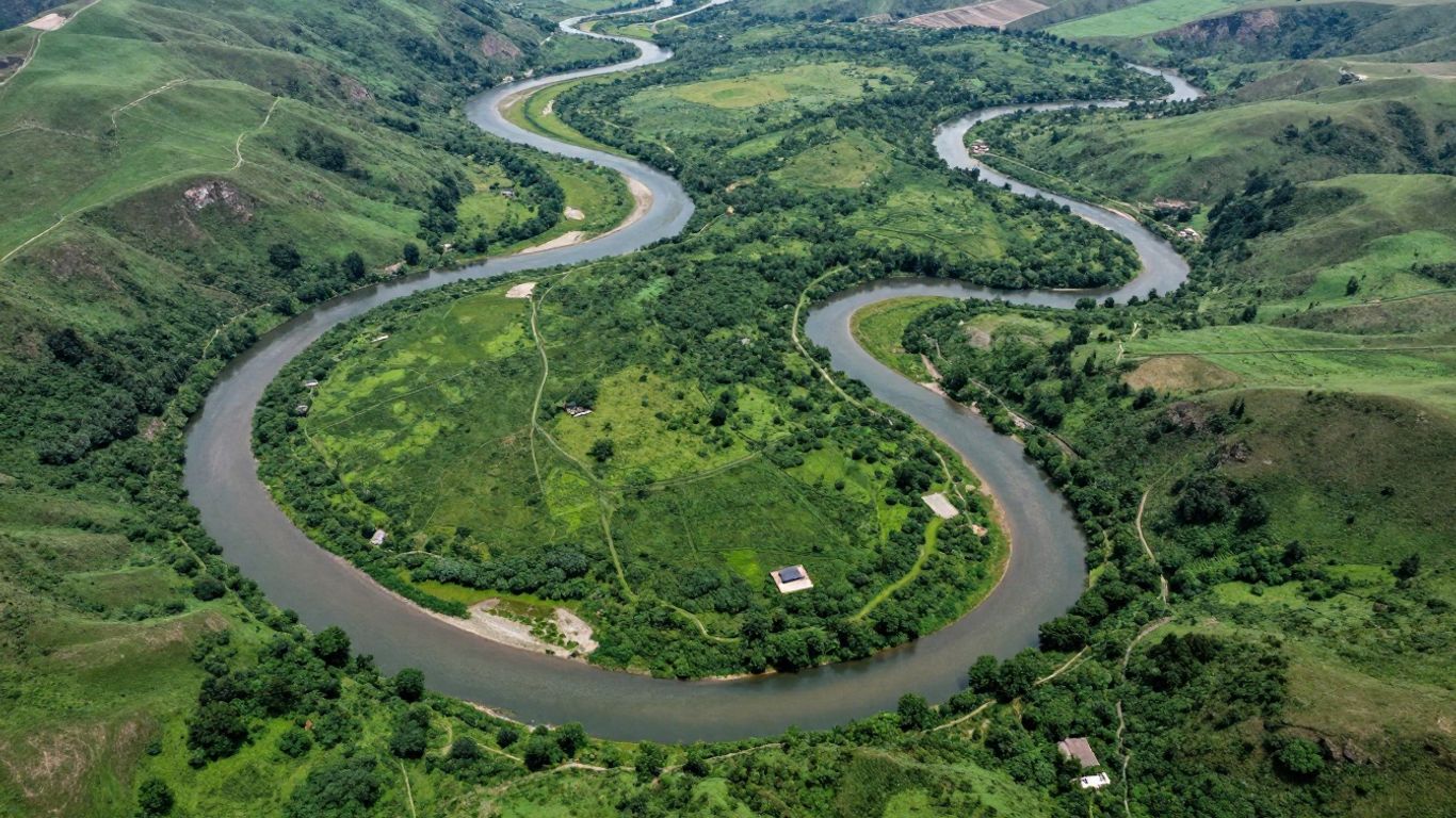
The Influence Of Watershed Shape
Next up is shape. Imagine a circular watershed versus a long, skinny one. In a roundish watershed, water from all sides tends to arrive at the outlet around the same time. This can cause a lot of water to pile up quickly, leading to a higher, sharper flood peak. Now, picture a long, winding watershed. Water from the far end takes a lot longer to get to the outlet compared to water from closer areas. This spreads the flow out, resulting in a lower, gentler peak that lasts longer. This difference is pretty important when you're thinking about flood control. It's not just about how much rain falls, but how quickly it all gets to the same place.
Measuring Watershed Length and Slope
We've touched on size and shape, but there are a couple more physical traits that really matter: length and slope. Watershed length is basically the distance from the outlet to the farthest point in the watershed, often measured along the main stream channel. A longer length, especially in an elongated shape, means water takes more time to travel. Then there's slope. This is about how steep the land is. Steep slopes mean water rushes downhill much faster, increasing the chance of erosion and flash floods. Gentle slopes slow water down, allowing more time for it to soak into the ground or flow more gradually. These factors, when looked at together, give us a clearer picture of how a watershed will respond to rain. For instance, research into how soil and rock permeability changes across landscapes helps scientists better understand these complex systems and their responses to evolving climate conditions, which is a key part of understanding hidden physics.
Here's a quick rundown of how these characteristics can influence water flow:
- Size: Larger areas collect more water but have slower peak flows. Smaller areas react faster with higher peaks.
- Shape: Circular shapes concentrate flow, leading to sharp peaks. Elongated shapes spread flow, resulting in gentler, longer peaks.
- Length: Longer watersheds mean water takes more time to reach the outlet.
- Slope: Steep slopes accelerate water flow and erosion. Gentle slopes slow water down.
When we talk about watershed management, understanding these physical traits isn't just academic. It directly impacts how we plan for things like floods, soil erosion, and even where we build roads or plan farms. Ignoring these basic physical features is like trying to build a house without knowing the ground it's sitting on – it's just not going to end well.
These characteristics are all interconnected. A large, flat watershed will behave very differently from a small, steep one. Quantifying these measurements, a process called morphometric analysis, helps us predict how a watershed will act and plan accordingly. It's all about getting a handle on the land's natural tendencies before we try to manage them.
Drainage Density And Its Implications
So, what exactly is drainage density? Think of it as a way to measure how well a watershed is crisscrossed by streams and channels. It's basically the total length of all the streams in a watershed divided by the total area of that watershed. We usually see it measured in kilometers of stream per square kilometer of land, or miles per square mile. It gives us a number that tells us how quickly water can get from where it falls to a main channel.
Understanding Drainage Density
Basically, a high drainage density means you've got a lot of streams packed into a relatively small area. Water doesn't have to wander too far over the land before it finds a stream to flow into. This means runoff happens pretty fast. On the flip side, a low drainage density means fewer, more spread-out streams. Water has to travel a longer distance across the land before it reaches a channel. This gives water more time to soak into the ground.
Here's a quick rundown:
- High Drainage Density:
- Lots of streams, closely spaced.
- Fast surface runoff.
- Higher peak flows during rain events.
- More potential for erosion.
- Low Drainage Density:
- Fewer streams, widely spaced.
- Slower surface runoff.
- More time for water to infiltrate the soil.
- Can lead to localized waterlogging if the ground can't absorb it all.
Factors Affecting Drainage Density
Several things influence how dense the stream network becomes in a watershed. Climate plays a big role; areas with heavy rainfall often develop more channels. The type of soil matters too – impermeable soils tend to lead to more surface runoff and thus more defined channels. Vegetation cover is another factor; less vegetation means more water hitting the ground directly, which can carve out more streams. And, of course, the type of rock and how easily it erodes makes a difference. Even human activity, like building roads and storm drains in urban areas, can dramatically increase the effective drainage density by creating new pathways for water.
What Drainage Density Reveals
This number tells us a lot about how a watershed will behave. A watershed with high drainage density is likely to respond very quickly to rainfall. This means flash floods can be a bigger concern, and there's a greater chance of soil erosion because the water is moving fast and carrying sediment. On the other hand, a low drainage density might mean slower runoff, but it could also mean that if the soil gets saturated, water might just sit there, causing puddles or local flooding.
Understanding drainage density is key for predicting how a watershed will handle rain. It helps us figure out if we need to worry more about fast floods or slow saturation. This information is super useful when we're thinking about things like building bridges or planning where to put new roads.
This metric is really important when looking at groundwater potential zones, as it gives clues about how quickly surface water might reach the water table or be lost to streams.
Interactions Between Watershed Characteristics
So, we've talked about watershed size, shape, length, and slope individually. But here's the thing: these characteristics don't just sit there in isolation. They all play together, influencing how water behaves in a watershed. It's like a recipe – you can't just throw in flour and expect a cake; you need the right amounts of sugar, eggs, and butter, all mixed in a certain way. The same goes for watersheds.
How Traits Work Together
Think about a big, sprawling watershed that's pretty flat. Water might take a long time to reach the main river, and when it does, it's probably spread out over a longer period. Now, picture a small, steep watershed. Water gets to the river much faster, and because it's all arriving around the same time, you can get a really sudden surge of water, which is basically a flood.
- Size and Shape: A large, circular watershed might collect a lot of water, but if it's shaped like a bowl, that water can concentrate quickly, leading to higher flood peaks than you might expect for its size.
- Slope and Drainage Density: Steep slopes mean water runs off faster, and if you also have a lot of small streams (high drainage density), that water has many paths to get to the main river quickly. This combination can be a recipe for flash floods and erosion.
- Length and Runoff: Longer watersheds mean water has further to travel. This can slow down the arrival of runoff at the outlet, potentially reducing the peak flow compared to a shorter watershed with similar slopes.
Predicting Hydrologic Behavior
Understanding these interactions is key to figuring out what a watershed will do during a storm. Hydrologists use something called morphometric analysis to measure these geometric properties. By looking at how size, shape, slope, and drainage density combine, they can get a pretty good idea of whether a watershed is likely to flood quickly, erode a lot, or release water slowly over time. This isn't just guesswork; it's based on how water physically moves across the land.
The way water moves through a watershed is a complex dance between the land's physical features. A steep slope might speed things up, but a wide, flat area could slow them down. It's the interplay of these elements that dictates the final outcome for water flow and potential hazards.
The Importance of Morphometric Analysis
So, why bother measuring all this? Because it helps us plan. If you know a watershed is prone to rapid flooding due to its shape and steepness, you can plan for better flood control measures. If another watershed is likely to have high erosion because of its slope and drainage patterns, you can focus on soil conservation efforts there. This kind of detailed analysis helps us make smarter decisions about managing our water resources and protecting communities. It's all about using the land's own characteristics to guide our actions, making sure we're not caught off guard by water resources.
Here's a simplified look at how different combinations might behave:
Practical Applications Of Watershed Knowledge
So, we've talked about what watersheds are and how water moves through them. But why does all this matter in the real world? Turns out, understanding these natural drainage areas is super important for a bunch of practical stuff. It's not just for scientists or environmentalists; it affects how we build things, grow food, and keep our communities safe.
Informing Flood Control Strategies
When we talk about floods, it's all about how much water a watershed can handle and how quickly it gets to a river or stream. The shape and slope of a watershed play a big role here. For instance, a round watershed with steep sides might funnel water down really fast, leading to quicker, more intense floods. Engineers use this information to figure out where to build things like retention ponds or levees. Knowing the watershed's geometry helps design better flood defenses. They need to know how much water to expect, especially during heavy rain. This helps prevent costly damage and keeps people safe. For example, understanding the drainage water management practices can be key in these strategies.
Guiding Erosion Prevention Efforts
Erosion is a big deal, especially in farming and construction. It's when soil washes away, often into our waterways, causing pollution and land loss. Factors like how steep the land is, how much the streams are packed together (that's drainage density), and how far water has to travel over the surface all point to where erosion is most likely to happen. If a watershed has lots of steep slopes and a dense network of streams, it's a red flag for potential erosion. This knowledge helps decide where to put in things like terraces, plant more trees, or build small dams in streams to slow down water and catch soil.
Supporting Agricultural Planning
Farmers have been working with watersheds for ages, even if they didn't call it that. The size and slope of the land directly influence what crops can be grown and how. On steep hillsides, you might see crops planted in rows that follow the contour of the land, or even trees mixed in with crops (agroforestry), to keep the soil from washing away. On flatter, well-drained land, farmers might be able to use more intensive farming methods. Knowing the watershed helps in planning for things like irrigation, drainage, and even where to put farm ponds for water storage.
Aiding Infrastructure Development
Building roads, bridges, and culverts requires careful thought about water. When engineers design these structures, they have to estimate how much water will flow through them during the heaviest storms. If they get this wrong, a bridge could get washed out or a road could flood. This calculation depends heavily on the size of the watershed that drains to that specific spot. A larger watershed means more potential water. So, understanding watershed characteristics is vital for making sure our infrastructure can handle the water it's designed for, preventing failures and saving money in the long run.
The physical traits of a watershed, like its size, shape, and how many streams it has, aren't just abstract measurements. They directly tell us how water will behave. This information is the bedrock for making smart decisions about managing our land and water resources effectively. Ignoring these basic facts can lead to plans that just don't work out as intended.
Understanding how water flows and what affects it is super useful in many real-world situations. From planning where to build things to keeping our drinking water clean, knowing about watersheds helps us make smart choices for our environment and communities. Want to learn more about how this knowledge can help you? Visit our website today!
Wrapping It Up
So, that's the lowdown on watersheds. It's basically the land area where all the water eventually flows to one spot, like a river or lake. No matter where you are, you're in one! What's cool is how everything is connected. What happens upstream, like pollution from your yard, can end up affecting things way downstream. Understanding these areas helps us figure out how to keep our water clean and manage things like floods better. It's not just about the water itself, but the whole landscape that guides it. Pretty neat, right?
Frequently Asked Questions
What exactly is a watershed?
Think of a watershed as a giant, natural bowl or basin. It's a piece of land where all the rain and melted snow that falls on it eventually flows downhill to a common spot, like a river, lake, or even the ocean. No matter where a raindrop lands within that bowl, it's all headed to the same place.
How does water travel in a watershed?
Water in a watershed moves in two main ways. Some of it soaks into the ground, becoming groundwater that can later join surface water. The rest flows over the land's surface, called runoff, heading towards streams and rivers. This runoff can pick up things along the way.
What are drainage divides?
Drainage divides are like the rim of the giant bowl we talked about. They are higher areas of land, like hills or ridges, that separate one watershed from another. If rain falls on one side of the divide, it goes into one watershed; if it falls on the other side, it goes into a different one.
Can watersheds be different sizes?
Absolutely! Watersheds come in all shapes and sizes. Some are tiny, maybe just a few acres feeding a small pond. Others are enormous, like the Mississippi River watershed, which covers a huge part of the country and collects water from many states.
Why is understanding watershed shape and size important?
The size and shape of a watershed affect how quickly water flows and how high the water levels get in rivers and streams. A round, steep watershed might cause water to rush to the outlet quickly, leading to fast floods. A long, flat one might spread the water out more slowly.
How do natural features help keep water clean in a watershed?
Many natural things in a watershed act like filters. For example, trees and plants along rivers and streams help trap soil and pollutants before they reach the water. Wetlands also soak up and clean water naturally, making it healthier.

