
Exploring the Vital Watersheds of New York: An In-Depth Look

New York is more than just big cities and tall buildings. It's also home to a huge network of water systems, called watersheds. These areas are super important for keeping the environment healthy, supporting the economy, and even shaping the culture of the state. Thinking about watershed new york helps us understand how water moves across the land and why it's so vital for everyone living here. We'll take a look at what makes these watersheds special, the big ones that define the state, and what we can do to protect them.
Key Takeaways
- Watersheds are areas where all water drains to a common point, playing a big role in ecosystem health and providing water for people.
- New York has several major watersheds, including the Hudson River, Susquehanna River Basin, Long Island's water supply, and the Great Lakes, each with unique features and importance.
- Maps of New York's watersheds are useful tools for education, scientific study, and helping officials make smart decisions about water management.
- These water systems are deeply connected to New York's economy, supporting agriculture, tourism, and trade, and have a rich history influencing its culture.
- Protecting New York's watersheds involves tackling pollution, managing water use, dealing with climate change impacts, and using conservation efforts like laws and community projects.
Understanding New York's Vital Watersheds
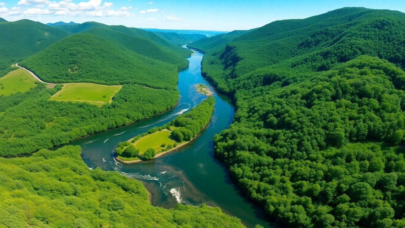
New York, a state often pictured with its famous city skyline, actually has a whole other side to it – a watery one. We're talking about its watersheds, which are basically land areas where all the rain and snowmelt eventually flows to a common spot, like a river or a lake. These systems are super important for keeping the environment healthy and making sure we have clean water. They help filter water naturally, support all sorts of plants and animals, and provide the water we drink and use every day.
The Essence of a Watershed
Think of a watershed as a giant funnel. Any rain that falls on the land within that funnel will eventually make its way to the same outlet. It doesn't matter if it's a tiny puddle or a big storm; gravity does its thing. This means what happens in one part of the watershed can affect everything downstream. It's a connected system, and understanding these connections is key.
Ecological Significance of Watersheds
Watersheds are like the lifeblood of ecosystems. They create habitats for fish, birds, and other wildlife. The plants and soil within a watershed also play a big role in cleaning the water before it reaches our taps. Wetlands, for example, act as natural sponges and filters, soaking up excess water and trapping pollutants. Without healthy watersheds, these natural processes break down, impacting biodiversity and water quality.
New York's Diverse Water Systems
New York is blessed with a variety of water systems. From the mighty Hudson River to the Great Lakes and the smaller streams that feed them, each watershed has its own unique characteristics. Some are heavily influenced by farming, others by urban development, and some are still quite wild. This diversity means that each watershed faces different challenges and requires different approaches to keep it healthy.
Key Watersheds Shaping New York
New York is a state with a lot of water, and it's not just the famous ocean coast or the big lakes. We've got these amazing river systems and underground water sources that really shape everything. Understanding these different watersheds helps us see how the state works, from farming to where we get our drinking water.
The Majestic Hudson River Watershed
The Hudson River is probably the most famous waterway in New York, and for good reason. It starts way up in the Adirondack Mountains, in some really wild, beautiful lakes. From there, it flows all the way down through the Hudson Valley, past cities and towns, and eventually meets the Atlantic Ocean. This river is packed with life; you can find all sorts of fish, like sturgeon, and bald eagles often hang out along its banks. The wetlands near the river are super important too, acting like natural sponges and filters for the water. Historically, the Hudson was a major highway for trade, and even today, boats still use it. Plus, it's just a gorgeous place for people to go boating, fishing, or just enjoy the scenery. It's inspired so many artists and writers over the years, giving us things like the Hudson River School of painting.
The Agricultural Susquehanna River Basin
Starting small near Cooperstown, the Susquehanna River might not be as famous as the Hudson, but it's incredibly important, especially for farming. This river flows through a big chunk of New York and then into Pennsylvania before heading down to Maryland and the Chesapeake Bay. The land around the Susquehanna and its smaller rivers is really fertile, and this water is what keeps a lot of New York's farms going. It's been a source of life for people for a very long time, from Native American tribes to early settlers who used it for getting around and trading. It's a workhorse of a watershed, quietly supporting a huge part of the state's food production.
Long Island's Critical Water Supply
Long Island has a watershed that's different from the big river systems. It covers all of Nassau and Suffolk counties, and its main water source isn't a river but huge underground pockets of water called aquifers. This is where most of the island's drinking water comes from, supplying millions of people every single day. Because so many people live there and there's also industry, managing this water is a big deal. They have to be careful not to take out too much water, and pollution from all the development is a constant worry. It's a delicate balancing act to keep this vital water supply clean and available.
The Great Lakes Watershed's Abundance
When you think of the Great Lakes, you might picture vast, open water, and that's exactly what this watershed is about. It borders the western and northern parts of New York, and it's part of an enormous system shared with other states and Canada. Lakes Erie and Ontario, which are part of this watershed, are full of life. They're home to many kinds of fish and are important stops for birds that travel long distances. These lakes aren't just pretty; they're also big economic drivers. Shipping happens on these lakes, there are important fishing industries, and tourism is huge, with people coming for the natural beauty and water activities. It's a massive, productive water system that New York is lucky to be a part of.
The Role of Watershed Maps in New York
Educational Empowerment Through Maps
Think about it: how many of us really see the water systems around us? Watershed maps change that. They take something abstract, like where rain goes after it falls, and make it visual. For students, this is a game-changer. Instead of just reading about rivers, they can see how a whole area connects to that river. It helps them understand that their actions, even miles away, can affect the water quality downstream. This kind of visual learning sticks. It builds a connection to the environment that textbooks alone can't always create. It’s about showing, not just telling, why these water areas matter.
Scientific Exploration and Analysis
For the folks who study water – the hydrologists, the environmental scientists – these maps are like their blueprints. They use them to figure out all sorts of things. Where does pollution come from? How does water move through the land? What happens when we build something new near a stream? Maps help them track these complex flows and patterns. They can pinpoint problem areas and figure out the best ways to fix them. It’s detailed work, and without good maps, it would be like trying to solve a puzzle with half the pieces missing.
Informing Policy and Governance
When it comes to making decisions about our water, maps are incredibly useful for the people in charge. They can look at a map and see which towns or industries are part of a specific watershed. This helps them create rules that make sense for that particular area. For example, if a map shows a lot of farmland draining into a drinking water source, policymakers might create programs to help farmers manage their runoff. It’s about making smart choices based on where the water actually goes.
Maps provide a clear picture of how land use impacts water. This visual data is key for creating effective regulations that protect our water resources without causing unnecessary disruption to communities and economies.
Here’s a look at how maps help in decision-making:
- Identifying Sources: Pinpointing where water pollution originates.
- Planning Development: Understanding how new construction might affect water flow and quality.
- Resource Allocation: Deciding where to focus conservation efforts or infrastructure improvements.
- Emergency Response: Mapping flood-prone areas for better preparedness.
Interweaving Economies and Cultures
New York's watersheds are way more than just bodies of water on a map; they're woven right into the fabric of how people live and make a living here. Think about it – these waterways have shaped our state's story for ages.
Watersheds as Economic Catalysts
These water systems are pretty much the engines driving a lot of what goes on economically. Take the Susquehanna River Basin, for instance. It's a huge deal for farming, providing the water that helps grow so much of our food. Then there's the Hudson River, which has been a highway for trade and still is, connecting communities and businesses. And let's not forget how these beautiful water spots draw people in. Places like the Finger Lakes or the shores of Lake Erie are big draws for tourists, bringing in money and jobs.
Here's a quick look at how some key watersheds contribute:
Cultural Chronicles and Historical Significance
Beyond the dollars and cents, our watersheds are like living history books. Indigenous peoples lived by these waters for thousands of years, and their stories are tied to the rivers and lakes. Later, explorers and settlers used them to travel, trade, and build communities. Every era has added its own chapter to the story of these waterways.
- Indigenous Heritage: Many tribes have deep spiritual and practical connections to specific rivers and lakes.
- Colonial Expansion: Waterways were vital for early trade routes and settlement.
- Industrial Revolution: Rivers powered early factories and transportation.
- Modern Recreation: Lakes and rivers are now hubs for boating, fishing, and enjoying nature.
These waters have seen it all – from ancient traditions to the hustle of modern life. They're not just scenery; they're part of our collective memory, influencing art, music, and local traditions across the state. The cultural landscape of New York is inseparable from its aquatic geography.
Navigating Challenges in New York's Watersheds
New York's watersheds, while incredibly valuable, face some serious issues. It's not all smooth sailing, and we've got a few big problems to sort out.
The Pollution Predicament
Think about all the factories, farms, and cities in New York. All of them can contribute to polluting our water. Chemicals from industries, fertilizer runoff from farms, and even sewage from towns can end up in our rivers and lakes. This isn't just bad for the fish and other critters living there; it also makes our drinking water quality a concern. Keeping our water clean is a constant battle.
Addressing Over-Extraction Concerns
More people and more businesses mean we're using more water than ever. Sometimes, we're pulling water out of rivers and aquifers faster than nature can put it back. This can mess with the whole system and, in the long run, might mean less water for everyone.
The Climate Change Conundrum
Climate change is hitting New York's watersheds too. We're seeing changes in how much rain or snow we get, warmer temperatures affecting how snow melts and water evaporates, and even rising sea levels near the coast. These shifts can really impact the water we rely on.
These challenges aren't just abstract problems; they affect the everyday lives of New Yorkers, from the quality of our drinking water to the health of our local ecosystems and the industries that depend on them. It's a complex web, and fixing it requires attention from all sides.
Here's a quick look at some of the main pollution sources:
- Industrial discharges
- Agricultural runoff
- Urban wastewater
And here are some of the effects of climate change we're starting to see:
- Altered precipitation patterns
- Changes in snowmelt timing
- Increased risk of coastal flooding
Championing Conservation Efforts
It's easy to feel overwhelmed when thinking about the big environmental issues facing New York's watersheds. But the good news is, there's a lot of work being done to protect these vital water sources. People are really stepping up, and it's inspiring to see.
Legislative Measures for Water Protection
New York State has put some solid laws in place to help keep our water clean. Think of things like the "Clean Water, Clean Air Bond Act." This isn't just a catchy name; it's a real commitment from the state to invest in making our waterways healthier. It shows a serious dedication to protecting the environment for everyone.
Community-Led Initiatives
Honestly, a lot of the real action happens at the local level. Grassroots groups are forming all over, getting people involved and making a difference right in their own backyards. These community efforts are so important because they build a sense of shared responsibility. When people feel connected to their local watershed, they're more likely to take care of it.
Here are some common ways communities are getting involved:
- Organizing stream clean-up days.
- Educating neighbors about responsible land use.
- Participating in local watershed planning meetings.
- Monitoring water quality in local creeks and rivers.
Protecting our watersheds isn't just about following rules; it's about actively participating in the health of our environment. These local efforts, big or small, add up to significant positive change.
Harnessing Technology for Monitoring
We're also seeing some really smart uses of technology to keep an eye on our water. Things like sensors that can track water quality in real-time are becoming more common. This means we can spot problems much faster and react quickly. Digital tools are making it easier to understand what's happening in our watersheds and to manage them more effectively. It's a modern approach to an age-old challenge.
Championing conservation efforts is vital for our planet's future. We're dedicated to making a real difference, and you can too. Explore how we're protecting natural habitats and supporting wildlife. Visit our website today to learn more and join the movement!
Looking Ahead: Protecting New York's Waterways
So, we've taken a good look at New York's watersheds, from the big rivers to the smaller streams. It's pretty clear these water systems are more than just pretty scenery; they're the backbone of the state's economy, its history, and frankly, our daily lives. We've seen how pollution and overuse are real problems, but it's also encouraging to see people and the state working on solutions, like new laws and local cleanup efforts. Maps are a big help in understanding all this, showing us where the water comes from and where it goes. Keeping these watersheds healthy isn't just a nice idea, it's something we really need to do, for ourselves and for everyone who comes after us. It's going to take all of us paying attention and doing our part to make sure New York's water stays clean and plentiful.
Frequently Asked Questions
What exactly is a watershed, and why is it important for New York?
Think of a watershed as a giant natural bowl that collects all the rain and melted snow from a specific area. All that water eventually flows to a common place, like a river, lake, or even the ocean. For New York, these watersheds are super important because they provide clean drinking water, support all sorts of plants and animals, and help with things like farming and recreation. They're like the state's lifeblood!
Can you tell me about some of New York's major watersheds?
New York has some amazing ones! The Hudson River watershed starts way up in the mountains and flows through the beautiful Hudson Valley, supporting lots of wildlife and being important for shipping. Then there's the Susquehanna River Basin, which is a big help for farms. Long Island gets its drinking water from underground sources in its own special watershed. And don't forget the Great Lakes watershed in western New York, which holds massive amounts of fresh water and is home to tons of fish and birds.
How do watershed maps help people understand and protect New York's water?
Watershed maps are like a treasure map for water! They show us exactly where the water flows, where it comes from, and where it goes. This helps scientists study water quality, helps teachers show students how water systems work, and helps leaders make smart decisions about protecting our water resources. They make it easier for everyone to see how connected everything is.
Besides providing water, how do watersheds affect New York's economy and culture?
Watersheds are big deals for New York's money and history! They help farmers grow food, support businesses that use the water for shipping or tourism, and attract visitors who enjoy boating or fishing. Culturally, rivers and lakes have inspired artists and writers for ages, and they've been important places for people to live and travel for thousands of years, holding many stories from the past.
What are the biggest problems facing New York's watersheds today?
Sadly, our watersheds face some tough challenges. Pollution from factories, farms, and cities can make the water dirty and harm wildlife. Sometimes, we use too much water, which can strain the system. Plus, climate change is messing with weather patterns, leading to things like stronger storms or drier spells, which can affect water levels. It's a lot to handle!
What is being done to protect New York's watersheds?
The good news is that people are working hard to protect these vital water systems! The government has passed laws to keep water clean, and everyday people are forming groups to help manage and clean up local waterways. Scientists are also using cool technology to keep an eye on water quality and spot problems early. It's a team effort to make sure New York's water stays healthy for everyone.

